This canyon is perfect for canyoning with friends, which is why we recommend first checking out all the local companies specialising in this activity.

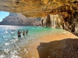
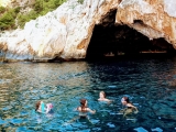
It's an extremely narrow canyon - in many sections you can touch both walls simultaneously. The Buitreras Canyon has been carved by the Guadiaro River, whose erosive force has shaped passageways and incredible cavities characteristic of karst landscapes.

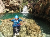
Adding to its beauty, certain drops that the river must overcome create impressive waterfalls. There are areas where darkness persists throughout the day, so when canyoning here you'll likely encounter bats.
The canyon's name isn't accidental - the griffon vultures inhabiting this area inspired the name Buitreras Canyon ('Vulture Canyon'). Access presents some difficulty due to the rugged terrain, making it one of the most renowned locations for adventure tourism activities like rock climbing and canyoning.

Access is via Puente de los Alemanes (German Bridge) or from Gaucín station car park. Entering via the railway is strictly prohibited and carries heavy fines. Leave cars at the power station before continuing to Puente de los Alemanes as mentioned.

When planning your Buitreras Canyon descent, note there are two distinct seasons for canyoning: the heavy rainfall period when descents become extremely dangerous and should be avoided, and the calm water season allowing for a more relaxed journey with small jumps and plenty of swimming sections.

Key Information
- Duration: 5 hours
- Rappels: 4
- Distance: 1.6 km
- Elevation change: 80 m
- Coordinates: 36.556595, -5.367588